Sunday, November 29, 2009

Gin Gin Rest Area - Thurs 26th November.


This is a very good rest area in a great small town.


Wide open park, space for many camps.


Super wide main street, two lanes each way divided by a wide median strip park plus parking on both sides of each carriageway. North bound lanes.


Northbound lanes again, taken centre of town.


The southern entry to the town main street.


Southern end of the southbound lanes.


Southbound lanes with two lanes of parking beside the centre median strip.

Thursday, November 26, 2009

Calliope River Rest Area - Wed 25th November.

On our way through to here from Bowen we stayed a night in Mackay with our great friends Ian and Sue and caught up with all their family and travel news.


The Calliope River Rest Area is fairly large and can accommodated quite a few vans, which makes it seem strange why they had one of the two toilet blocks closed. Believe me, it was a long hike to the toilets when you need to get there! The day was heavily overcast and we had some rain on the way down, how depressing! We got here and then we were bombarded with gritty black dust, we think it may have come from the smelter at Gladstone. We wont be in a hurry to camp here again, there are other places!

We had just set up camp and a bus load of school kids arrived, from South Gympie Primary School they told us. Lucky for us their stay was only short.


From our camp site looking down upon the old disused causeway. There is camping on the other river side as well, accessed by a road off the Bruce Highway about 2 km south of here.

There weren't many campers here when we set up but by nightfall all the better positions had been taken.


Our camp site from the other side of the river.


The Bruce Highway bridge over the Calliope River from the causeway.


Bowen - Thurs 19th to Sun 22nd November.

Prior to reaching Bowen we did spend two nights in Townsville. We weren't doing the tourist thing, just shopping for needed camping equipment and making some essential repairs.


The pace of living is so much slower here at Bowen, more to our liking. The Tropical Beach CP had been recommended to us but when we arrived there we were greeted with a strong odour emanating from the sea. We moved on to The Harbour Lights CP directly opposite the Boat Harbour. We later learned that the foul odour we encountered on our arrival was from coral spawn. The spawn was clearly evident in the water and currents carried it away by the next day.


You can just make out the coral spawn in this shot from Flagstaff Hill. Look from the left point of the island back towards the mainland.


From the same vantage point, Bowen Town looking over the boat harbour.


Next visit we will stay in either Horseshoe Bay CP or Wangaratta CP which are located either end of Queens Bay.

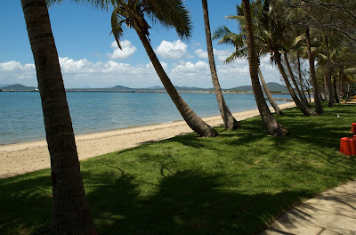
This is Queens Beach looking around Queens Bay towards Horseshoe Bay at the far end. Wangaratta CP is located here in Queens Beach.


Some of the park alongside Queens Beach.


Sunday Market at Queens Bay, 2nd and 4th Sundays each month.


The fishing must be OK here as there are many boats going out from the harbour. The boat ramp is visible from our camp site. The foreshore in the town area has been newly redeveloped since we were here last at a cost of $11.4 million and in fact was only officially opened the weekend prior to our arrival.

View to the south of Port Denison.


View back towards Boat Harbour.


A memorial to the Catalina  Squadrons that were based here during WW 11.


Memorials to all theatres of war that Australian Servicemen and Women went to and did not return.


Also part of the development is this Visitor Information Centre and behind it a Sound Shell.


This weekend the foreshore development has been hugely popular with many families pic-nicing and having BBQs over the Saturday and Sunday.

Another great area in town is Mullers Lagoon. The parkland is 23 hectares in total with half that area taken by the lagoon.


Mullers Lagoon is centrally located in Bowen with residences evident here.


Saturday, November 21, 2009

Reid River Rest Area - Mon 16th November

After pausing for a few hours in Ravenswood we didn't attempt to drive direct to Townsville but elected to stay over at The Reid River Rest Area for the afternoon and night. This only left a short 50 km drive to Townsville the following morning.

View from the Rest Area looking towards Townsville.


View of the Rest Area to the south.


This view of the Rest Area is more northerly.


The railway bridge over the Reid River. Another wide sandy bottomed river with no water.


Reid River in the other direction with the road bridge, Flinders Highway.


The following two nights we will be staying in a CP in Townsville. As we are going to be busy restocking the larder and looking for other essentials, like comfy camp chairs and not doing the tourist thing in Townsville we will not be posting to the blog from there. The next post will be from Bowen.


Friday, November 20, 2009

Ravenswood - Mon 16th November

On our return travel from The Burdekin Falls Dam we turned off the road into the very small, but still active, mine  town of Ravenswood that is 40 km from Mingela and the Flinders Highway. Ravenswood is an historic gold and silver mining town complete with all the old mining relics and some of the old buildings still intact. We didn't stay over in Ravenswood but had a short walking tour of the central town area.

We parked the car and van at this convenient rest area in town and went for a foot tour.


The old Court House that is now a museum.


The Railway, one of two hotels in town.


The Imperial Hotel, the other pub.


The original Post Office is still in operation. The red phone box is for show only!


The Ambulance Station now used by the Flying Doctor who visits each month.


The central intersection of the town. The white steps once led into another pub, 'Browns Hotel', that unfortunately burned to the ground.


The larger building once had the dental clinic upstairs and a furniture shop on the ground floor.


I don't know what this building once was but now it is full of 'bric-a-brac'.
The sign near the door says, "gone for a cuppa, be back in a while"


The town hall, with an outdoor function area to the left.


At the Ford dealers, two trucks waiting for pre-delivery service!


Across the road, a lot more modern car dealer, an Austin A30, I believe.


There is an open pit gold mine here that ceased production about two years ago. Now the company is bringing ore from another operation 11 km to the north of town and processing that in the plant here. The waste material is being back filled into the old open pit.

This is the old open pit that has only been closed down in the past two years. You can clearly see that the company is now back filling the pit with waste material from another mine 11 km north of town. This look out point is gained by walking a very steep concrete path: 1:10 gradient.


I used the look out point at the mine to shoot a couple town panoramas, this is looking over the south end of town.


This is looking over the northern part of town. There is a lot of open space between buildings because many of the old buildings have been destroyed by fire or decay.

Wednesday, November 18, 2009

Burdekin Falls Dam - Thurs 12th to Sun 15th November

This park, operated by SunWater, on the site of the dam construction town, is an oasis of green in a fairly barren landscape.

Dalrymple Reservoir with Mount Mc Connell in the back ground.


Part of the Camp Park.


Some of  the day visitor area.


One of the resident peacocks with the employee housing in the back ground.


It is fairly hard to see, but centre photo is the viewing platform accessible from the day visitor park. This shot is taken from the dam spillway.


This is the view from the lookout platform in the previous photo.


The park is also at the end of the bitumen road, 120 km from Mingela on the Flinders Highway. At this time, only a month or so from the 'Wet Season', the Dalrymple Reservoir is still fairly full. One or two decent downpours and the water will again be cascading down the spillway.

The day visitor and camp parks are on the crest of the hill beyond the dam.


There are several walks available (not marked) and the fishing is excellent for those who have a permit. The reservoir is also a popular water sport haven, with several ski boats and Sea-Doos scorching around the crystalline water over the weekend.

Ski boat on the reservoir centre photo, the boat ramp is just right of where the boat is.


It is much quieter on a weekday. This is also a great park for families, not much harm can come to kids, they can pretty well wander where they choose and they love the swimming pool (salties are known to be in the reservoir). The dam is one of the largest in Queensland and probably Australia, and took five years to construct.

Look closely at the road way at the bottom of the spillway, mid photo you will see a semi trailer truck and a motor home following. This shot demonstrates the magnitude of the dam wall.


Down stream from the spillway. With minor flooding, 10,000 m3/sec, all these rocky areas are covered in water flow.


The Dalrymple Reservoir goes back for over 20 km.


Full shot of the wall looking back to the camp park.


The wall height can be extended and there is provision to add a hydro power station. I guess they wont increase the capacity as they don't use most of the water that they have stored now. But why aren't installing an hydro power station now? There is water flowing from the 'pentstocks' continually therefore the power generated would be base load and virtually free.

The water is released to flow down the Burdekin River under the road way.


The Burdekin River Falls, hence the name of the dam wall.