Thursday, March 31, 2011

Cradle Mountain NP

We studied the weather charts and determined that it was going to be ideal conditions to visit Cradle Mountain on Monday. Soon after lunch on Sunday we pulled into the free camp at Gowrie Park. This is a large area beside the Rodeo Park. In the 2 to 3 hours after we set up camp at least another 6 vans pulled in, all with the same intentions. About half the campers were Queenslanders. It was a bit like a reunion. There is a Caravan Park in the town but this free camp was utilised by many like us, just wanting a step-off point to visit Cradle Mountain. The National Park was only 38 km away. The Monday dawned mild and clear with the temperature rising to about 14 C while we drove to the NP. By the time we finished the Dove Lake Circuit we were in a sweat. On the Tuesday there was a mass exodus from Gowrie Park, only about 3 camps remaining after we left. We travelled about 40 km to Lake Barrington, another 'hydro' lake, and made camp for the night. Soon after, a motorhome pulled in and the people were from Buderim. They decided to stay and we had a great chat about our respective travels in Tasmania.


At the entrance to the free camp at Gowrie Park is this giant poster board with a mural depicting the view from this point prior to settlement in the area.

We are surrounded by peaks at Gowrie Park. This is the road into town from the camp area. Gowrie Park was a 'hydro' town and boasted a population of many hundreds during the construction phase of the hydro scheme but now there are the residents of two homes.

Another of the peaks behind the hydro office.

Yet another of the peaks behind the only two remaining homes here.

A Bucket Wheel from one of the power stations. There are two buckets on each blade that are each driven by nozzles ejecting water with a 300 metre head of pressure. The turbine drives an alternator producing 15000 amps of power.

This is only part of a mural on the back wall of the Hydro Maintenance Workshops.

Looking over O'Neill's Creek into the free camping area.

The beginning of our hike around Dove Lake. The sky is clear and sunny but the air is still crisp.

Further around and the mountain is still imposing it's presence.

Along the way we came across this wallaby that seemed unperturbed by the large number of walkers on the track.

The Boat shed beside the crystal clear waters of Dove Lake with the mountain still there in the background. Two hours after our departure and the temperature has changed, everyone is shedding clothes by this stage.

After a quick lunch we took the shuttle bus out to Ronny Creek to begin the two hour walk back to the Ranger Station. The entire walk is on the boardwalk, very easy.

This is Ronny Creek.

There are large areas of this low shrubby fern.

Jude walking the plank down to Ronny Creek.

An entire 'meadow' of Button Grass. This, you will recall is what adds the tannin colour to all the water in the creeks and rivers.

Very near the end of this lovely walk. When we got back to the car and started driving home to the camp we discovered that the temperature had risen to 20 C.

Lake Barrington, the home to a lot of water sports. Although it is very pretty here we only stayed one night as there is no where to walk. You can see by the photo that the banks go steeply into the water, it's like this all the way around.


Monday, March 28, 2011

The Northwest Corner

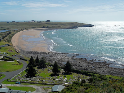
After completing a full itinerary at Strahan, in beautiful weather, it rained on the last night. The next morning the rain eased so that we could pack up and travel the short distance to Zeehan where we made camp. That afternoon we drove out to Trial Harbour, as a fellow traveller told us it was worth a look. Trial Harbour was the first anchorage on the west coast until Strahan Harbour was established. After a walk on the beach, in gale force winds and stinging sand we visited "The History Room" at a private home. We got talking to the lady of the house and bought some vegies from her garden. There is no power to this community so every house has solar power, wind power or both. The wind power seemed to be totally effective on the day we visited. We had planned to drop into the Pioneer Museum and Gaiety Theatre at Zeehan before we left town but the day was raining and miserable so we motored on. As we travelled further north it rained even harder. We had planned to stop over at Waratah and use this as a base to travel to Cradle Mountain. Due to the low cloud and rain we continued on to the north coast and camped at Crayfish Creek CP. This park is nothing special but it is protected from the wind and it is central to the north west area. Over our three day stay in Crayfish Creek we ventured to Stanley and Arthur River. Arthur River is self titled "The End of the World". Well maybe it's not but you can see it from there.


Overlooking part of the Trial Harbour community with the strong easterly blowing spray off the breakers.

There was some big surf coming onto the west coast.

The garden at the back of the house with "The History Room". The outlook takes in the very small Trial Harbour.

At the north end of town is a camping area, complete with leeches I might add, I had one attached to my leg. Some industrious persons built a rock wall at the base of this small waterfall and created a swimming/spa pool on the beach.

Looking southwards from the camp ground back over Trial Harbour towards the community.

There's not much at Zeehan! This is one end of the Main Street. The restored Gaiety Theatre is on the left. I would have taken a photo of the facade except that the local real estate agent had his blue ute parked in front of it.

This is the other end of the Main Street.

There is a good park with excellent facilities for travellers.

On the approach to Stanley along the coast one is confronted with this majestic sight.

Strahan Harbour full of 'crayboats'.

We haven't reached the top of the 'Nut' yet and already the views are stunning. This is looking west.

We are under the chair lift and looking east over the major part of town. Still not a the top, we had to take several rest stops.

Just to prove that we made it to the top. This is what it looks like. Of course we could have taken the wimps passage up on the chairlift.

Two intrepid travellers on the extreme west coast of Tasmania. Tasmanians call it "The End of the World"

There is a huge amount of drift wood washed up on the beaches here. The outflow of the Arthur River is in the background.

Much of the drift wood is whole trees. The only footprints on this sand other than ours were from wallabies.

The Arthur River flowing, under the single lane bridge, out to sea to the right.

On our way home from Arthur River we drove into Dip Falls. The turn off was only about 8 minutes short of the Crayfish CP. Again this was a fellow traveller recommended attraction. We walked down 165 very large steps to see this view of the bottom section of the falls. The brown 'tannin' stain is clearly evident in the water coming over the falls. Most of the drinking water all over the west coast has this stain in the water, they say that it isn't harmful to humans.

Back up on top again. This is the top section of the falls. You can just make out the beginning of the bottom section of the falls on the extreme left of the photo.


Sunday, March 27, 2011

Strahan Part 3

We have been in the Tasmanian wilderness again, spending 3 days without phone or internet connection, how do these people survive? We left Strahan nearly a week ago and I'm still trying to catch up with the travel reports and photos. It's almost to the stage of not remembering what we did there!


The final major tourist attraction we wanted to experience was the West Coast Wilderness Railway. This railway was originally used by Mt Lyell Mining to haul the output from the Queenstown mine but was pensioned off in 1963. With the aid of Bi-Centenary Funding the railway was bought back to life as a tourist attraction and is very popular to this day.


The carriages and the Strahan railway station of the West Coast Wilderness Railway.

This was to be our locomotive for the initial section of the trip to Queenstown. This diesel locomotive is used for the less steep sections of the rail line.

As we leave Strahan we follow the King River. You might notice by the colour of the water and the sterile river banks that it is polluted with the effluent from the Mt Lyell Copper Mine.

At one of our stops along the way we discovered this old wooden bridge in the forest.

This is one of the many steel trestle bridges that we cross on our journey.

Jude is listening for the whistle of the next train to come along.

The pollution of the water and the silt from the tailings is quite evident in this shot.

The forestry and local schools have been busy planting grasses and trees along the river in an attempt to revegetate the river banks.

This photo shows the Queen River. The Queen flows from Queenstown and joins the King River. The Queen River shows the effects of the mine pollution far more than the King River. You can just make out the relic of an old timber structure destroyed by floods many years ago.

Looking upstream crossing the Queen River, here you will see the remans of an old steel bridge destroyed by the same floods.

Track workers waiting for the train to pass.

At the half way point is "Dubbil Barril Station", here, while the passengers enjoy the lunch break, the diesel locomotive is replaced with the steam locomotive. Here the steam locomotive is moving onto the turntable to be readied for it's return journey to Queenstown. 

A peek in side the driver's compartment.

The turntable is hand propelled by the driver and the fireman.

The funnel and whistle are polished copper.

The steam locomotive shunting the carriages to the platform for us to board. The steam locomotive uses the 'ABT' traction system. The ABT system is a pinion drive under the engine that engages a rack fastened onto the railway sleepers. Here you can clearly see the  rack positioned between the two rails.

It is not really clear here but there are two pinion gears under the engine that engage with the rack. These pinion gears are driven independently of the wheels and the push rods can be seen behind the wheels.

Another glimpse of the greatly polluted Queen River.

As we view the Queen River once more we are climbing an incline at a ratio of 1 in 20. Without the ABT system this would be impossible.

We had one final stop to have a quick look at this abandoned mine.

And this is the name of the mine. From here onto Queenstown we are travelling downhill at the ratio of 1 in 16.