Monday, October 26, 2009

Cloncurry - Thurs 22nd October

Another early rise, breaky, pack up and continue on our journey. Today our destination is Cloncurry or as affectionately known by the locals, "The 'Curry". Cloncurry is situated on the Flinders Highway 118 km east of Mt Isa or a damn long way from Townsville, 774 km to be more precise. The Curry has a population of 3500 to 4000, depends what statistics you read, and mostly relies on the mining industry in the region. Not a bad little town that seems to provide most necessary services, including an outdoor picture theatre. Sorry no photos to support my blog, it was a hot day and the dog (Lizzie) would not walk, I had to carry her, therefore I could not carry the camera too. Well, that's my story and I'm sticking to it. I promise to shoot some photos when we leave The Isa and head back east. Watch for updates to this blog item at a later date, I'll let you know when.


Well, here they are!


First shot of the CBD.


The blokes corner, the pub and the hardware shop.


The Town Hall and Information Centre.


For Sale, contact owner at the house.


An early steam powered tractor located at the Mary Kathleen Mine and Museum Park.


Also at the park was this hand winched railway crane with rolling counter weight.


Chinaman's Creek Reservoir, about 3 km out town.


The Walkabout Creek Hotel at McKindlay, as featured in "Crocodile Dundee". McKindlay is 74 km from Kynuna on the Landsborough Highway. The car engine is still running, I only stopped for the photo shot.


Kynuna - Wed 21st October

Today and the following 2 days we are, basically in 'Transport Mode', on our way to Mount Isa. We departed Ilfracombe CP fairly early and drove the 27 km to Longreach. Here we stocked up on all the essentials, like fuel, food, beer and items from the bakery that we had been told about. We drove out to the Longreach Waterhole on the Thomson River, a fishing and free camping area, and had morning tea with the goodies from the bakery, an indulgence.


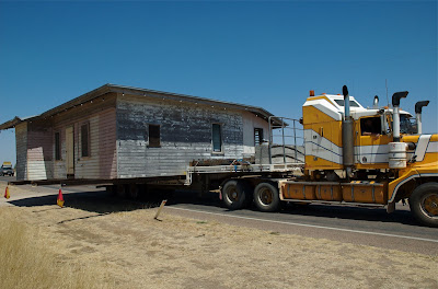
Then on the road again towards Winton, where we stopped for lunch. Yes, eating again! While eating our salad lunch we noticed a wide load escort vehicle with flashing amber lights nearby. As this escort vehicle did not move after several minutes I had to investigate. The load that was being escorted was an entire house, as wide as the roadway. 


Apparently, the story goes, the house had been taken to Hughenden as a 'prop' for an Australian Movie and was being returned to Winton and placed on a block there. After all that excitement we travelled onto Kynuna and the 'legendary' Blue Heeler Hotel. 


We set up camp behind the hotel, had a beaut hot shower and went over to enjoy the hospitality of the publican.


After several stubbies of XXXX Gold the clock moved around to 7 pm. We asked the host, "What time did dinner come on?" "What dinner" she replied. "I'm the only one here and can't be everywhere at once." There were travellers, similar to ourselves, transport drivers, cattlemen and fishermen returning from the Gulf, over 20 people in total. The publican missed out on the revenue from the meals and also beer sales as we all left the premises. Some like us, to our own devices, others like the fishermen went to the roadhouse only 200 metres away. What a poor way to run a business!


The Kynuna Roadhouse.


The "Real Story"? Looks like a "Sad Story".


Tuesday, October 20, 2009

Ilfracombe - Mon 19th & Tues 20th October

Ilfracombe is a very small town on the Landsborough (Matilda) Highway, 27 km east of Longreach. We have buzzed through this town on several trips to Mt Isa and have often thought to ourselves, we must come here, stay a while and see what the town has to offer. Commercial enterprises consist of, a caravan park, a hotel, a post office, a cafe come everything store and the shire offices.


The sole remaining pub in town.


The cafe and come everything general store.


There is a school, sporting facilities and a swimming pool which also includes the artesian water spa.


This warm artesian water is is working wonders, pummelling on my back muscles.


Judy was also lapping up the spa action. We had it all to ourselves for over three hours.


What is most visible in the town though is the machinery and historical museum. This museum covers the entire northern side of the highway through the town, a distance we believe is 1.6 km.


Most of the machines on display have a plaque with their description and where they were used.


This pavilion is only recently erected, officially opened September 2009.


The display just keeps going on.


More historical exhibits.


A monster tractor from a time past.


An ingenious trailer set up, the centre wheels propel each individual trailer and are driven by a drive shaft that is connected from trailer to trailer. The other two axles on each trailer are steerable and cross linked with cables so that each trailer tracks precisely in line with the towing vehicle. It is claimed that the assembled road train can travel along a fence line and then turn through a gateway.


Monday, October 19, 2009

Isisford, OMA Waterhole - Sat 17th to Mon 19th October

While we were camped on the Barcoo in town, we met some other campers and began talking, as you do. One couple said they were going to move out to the OMA Waterhole as the fees we paid in town were transferrable to that site. So we all moved out, it is only 15 km from town.


Our camp site on the river bank.


The river view from near water level, our camp sight is about 6 m above this point. There are steps cut into the river bank to access the river.


The OMA Waterhole is also part of the Barcoo River and is the site of the Annual Isisford Fishing Competition held mid year if conditions suit. If it rains you would not be able to get into or out of here. The road is gravel but smooth, no corrugations.


As this is the site of the fishing competition, there are good toilets and hot showers provided, for $2 per night or $10 per week. What a good deal.


Facilities for the Fishing Competition with the hot showers and toilets in the background. There is also Telstra Next G connection out here (3bars).


If you want solitude, this is the place to come, it is sooo quiet here, it's beautiful. The camp area stretches about 4 km along the river so it is easy to find a camp spot away from others. Except when the fishing comp is on I would expect. There is also a very good boat ramp here, as you would also expect.


This area was once populated, there are the remains of old fences and farm buildings scattered around the area. This is one of a couple of old pumps left behind. A couple came into the camp yesterday and we began talking, exchanging travel itineraries etc. He said he used to come here as a kid and he can remember that there was an old guy growing vegies, about where this pump is located.


We are breaking camp again this morning, as good as this place is we are moving on, Ilfracombe is the next stop, about 105 km from here.

Isisford - Wed 14th to Sat 17th October

We had originally planned to travel onto Barcaldine from Blackall but as we intimated in an earlier post, a change of direction was also possible. A chance encounter at Augathella with a couple of Victorian travellers heading home and their recollections of camping at Isisford prompted a re-appraisal of our intentions.


We left the highway at Blackall and turned onto a minor road towards Isisford, this road is in good condition but fairly narrow. We had to leave the road on several occasions and let the cattle road trains have all the bitumen. We drove through some prime pastoral land, home to some large stations with names such as 'Isis Downs' and 'Thornleigh Creek Station'. Although we noticed many prime cattle along the roadside, we also saw many emus with chicks and brolgas.


Camp fees at Isisford are quite reasonable at $2 per night or $10 per week. We camped on the bank of the Barcoo River in a secluded niche amongst the trees (not river gums).


The river view from our camp.


Well maintained toilets and drinking water was supplied, no showers. We used our own external shower for the first time here and found it most satisfactory. We could walk into town for our food supplies.


The road into town from the west.


The Golden West, one of two pubs in town.


The other pub, Clancy of the Overflow. Where Banjo Paterson found inspiration for his writing. The owners must have faith in the future of the town as there are extensive refurbishments underway.


More of the main street.


Every country town seems to have a museum. This one had photo collections in albums and comfy chairs to sit and view them.


The museum and historical park are behind the Isisford Shire Office (now part of Longreach Council).


Saturday, October 17, 2009

Blackall - Tues 13th October

Blackall is located on the Landsborough (Matilda) Highway, 107 km south of Barcaldine. Following the plan of many Queensland outback towns the streets are very wide with generous median strips dividing the traffic.


Notice the tourist information board, bottom left of the photo, these are situated at buildings and points of interest in the town.


This gives the towns a "wide-open" feel of spaciousness like the wide open lands the towns have settled into.


This is one of the 'cross streets' intersecting with the main street. The old petrol bowser, left of photo, has a price per litre of 73 cents, obviously it has been shut down for quite some time.


It seems as though the north end of the town is being redeveloped to a greater extent, with businesses located in newer buildings. There is a great facility, the north end of town, for the aged beside a large Ambulance Station. No, I'm not looking to go into there just yet. Meanwhile the south end of town does have the Community Centre.


The entrance from the street to the Community Centre.


This is the main entrance to the Community Centre,


Blackall claims to be the 'home' of the Black Stump. Sadly, the original stump was burned out and has been replaced with a petrified tree stump in the same location.


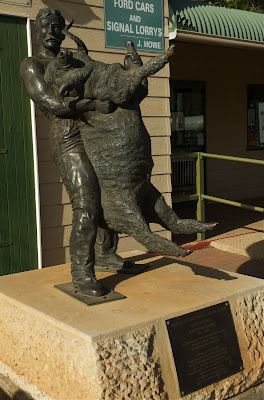
Blackall also claims "Jack Howe" legendary sheep shearer and record holder of most sheep shorn in one day. 321 sheep in one shift of 7 h 40 m. (not with my back thanks)


Yet another Blackall claim, this is proclaimed to be the first bore put down to The Great Artesian Basin, oddly, Barcaldine also makes claim to this distinction.


The drill rig that was used for the first bore attempt.


The Masonic Lodge, constructed in the 1880's, still in use today, and in very good shape. The verandah was not part of the original construction but was added in the early 1900's.


The CP is small and cramped with old broken concrete pads and old but clean amenities.

Thursday, October 15, 2009

Augathella and Tambo Tues 13th October

After extending our fair-wells at Charleville we made tracks for Blackall on the Landsborough Highway also known as the Matilda Highway. Before we reached Blackall however we had to travel through the small towns of Augathella and Tambo. We stopped at Augathella for our morning tea break and met some Victorian travellers heading south. They informed us of their stay at Isisford and that that they enjoyed it immensely. We placed this information in our memory banks for later use. 


Stopped at Augathella for morning tea, the car and van combination is performing beautifully.


We travelled on to Tambo for lunch by a lake. 


The van only takes about 1 minute to pop the top to prepare lunch, no effort here at all.


We were welcomed by a bunch of ducks and two roosters of unknown breed, they had lots of ruffled black plumage. 


Jude with her duck friends, the pecking intruder is under the table.


One of the ducks persistently pecked Jude on the leg for food. Jude escaped by hopping onto the table to finish her lunch. Having survived the lunch time experience we travelled on to Blackall.

Wednesday, October 14, 2009

Charleville - Sat 10th Oct to Tues 13th October

Charleville is 275 km west of Roma at the junction of the Warrego and Mitchell Highways. We arrived in Charleville about lunch time on the saturday, after we set up camp and had a light lunch we went into the town, we were practically alone there, everybody had gone home! Closed shops and vacant car parks galore. So, we learnt something, there is no business in Charleville after 12 noon saturday until sometime monday morning. Similar to many outback towns, Charleville is a town of very wide streets, with grassy median strips down the centre, some of then with garden vegies like silverbeet, we picked a couple of serves. The following two shoots were taken Monday morning.


We stayed at the Bailey Bar CP, a Top Tourist Park with permanent residents! The amenities were not too bad but the sites were a bit cramped for space. We chose three of the windiest and dustiest days to stay there.


As all these towns use artesian water for their town supplies, users have to adopt different principals when having a shower. As the water comes from the bore "hot" there is no "cold" water as we know it. So you start your shower with just "cold" water and if this is not hot enough for you then had some "hot" water from the water heater. It is not often that you have to use the hot water tap.


We met Michael and Judy at Mitchell and ran into them again at Charleville. Had "happy hour" each day with them and anybody else that came along. On Monday Michael invited us  and two other couples for "tea at three" which included a "secret recipe damper" with jam and whipped cream (really came from the Womans Weekly), this was delicious. Three o'clock ran into four o'clock and then it was "happy Hour" again! Tuesday morning we swapped e-mail address and mobile phone numbers with Michael and Judy and left Charleville, heading for Blackall.


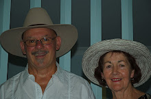
Michael, extreme left and his wife Judy, extreme right. The other two couples were from adjoining camps, the two women were sisters. Judy and I didn't get into a photo.


Graham Andrews Parklands hosts the Outback Native Timber Walk, Steiger Vortex Rainmaking Gun and water course complete with many water birds.


Some old steam engines, with the vortex gun in the background.


The Steiger Vortex Rainmaking Guns. They were a failure in their purpose of making rain but were apparently very spectacular in other ways, they were known to explode, probably with an overdose of charge. You know the adage, more must be better!


A couple of posts ago I posed the question: why was the water blue in one of the photos I took of the Moonie River? Well, the answer is refraction of light, have the sun behind you and refraction of light rays causes the water to look blue instead of muddy.